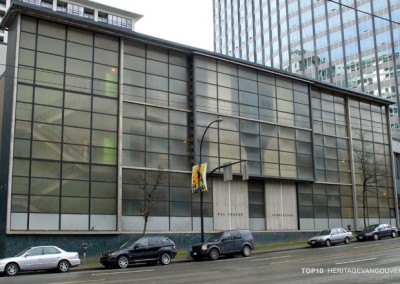
One of Vancouver’s oldest neighbourhoods, rich in residential, commercial and industrial heritage, but the area is currently being ignored. If the City doesn’t act soon, there will not be anything significant left of this historic area’s early history.
Significance
Why is Lower Mount Pleasant significant?
Mount Pleasant is one of Vancouver’s oldest neighbourhoods, rich in residential, commercial and industrial heritage and layered with numerous and diverse community memories and stories. This was one of the first areas outside of downtown to be developed for residential use, and is a direct connection/example of the development of early Vancouver, mainly from the first extensions of the streetcar lines enabling it’s growth.
There are many surviving historic structures in the area, especially north of Broadway, the part of Mount Pleasant that developed first. These early buildings illustrate the city’s first development.
One example is the Lindsay Residence (1888), a Victorian residence at 144 East 6th Avenue, possibly the oldest house outside of downtown.
Another is the 1892 J.W. Clark Building (1892) at 2313 Main Street, likely the oldest commercial building outside of downtown. Neither of these buildings is on the Heritage Register.
Threat
What is the threat to Lower Mount Pleasant?
One of Vancouver’s oldest remaining neighbourhoods is quickly shedding its historic roots.
The City of Vancouver has embarked upon a community consultation process to update the 20-year old Mount Pleasant Community Plan. This plan, however, excludes the semi-industrial area north of Broadway, bounded by Main and Cambie Streets and 2nd Avenue, which still contains a rich variety of early heritage buildings.
This area was zoned industrial many years ago, and is now seen as an area that has further potential for job creation, likely through denser redevelopment.
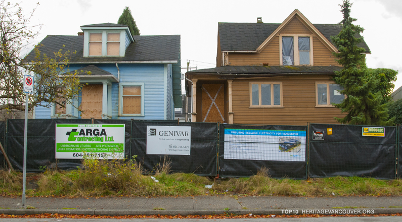
Few buildings in this area have made it onto the Heritage Register, and even fewer are designated. Due to Vancouver’s high land values, and changes in zoning, the remaining houses are under increasing pressure for commercial redevelopment, and demolition.
Already in the last few months of 2009, a number of homes have been demolished, including a beautiful fairly unaltered 1912 home at 122 West 8th Avenue, also 1832 Columbia Street (1904), a building most recently known as Molly’s Dinner, a 1904 home converted years go to commercial use, yet still retaining it’s historical roots and charm.
Since most of the houses in this area are not on either the heritage register or designated, demolition permits are freely penned without any indication that a perfectly preserved example of the areas history is about to become landfill.
Also currently on the chopping block are two early homes, circa 1905, awaiting their date with the wrecker’s ball, at 302 & 304 West 6th Avenue. The properties were purchased by BC Hydro, to make way for a substation due to the new development in the area.
304 W 6th Avenue (1905) at Alberta Street
Up until last year, the house at 304 West 6th Avenue still retained its original gingerbread detailing at the roofline, along with original double-hung wood sash windows.
Hydro had offered the houses for $1.00, with the stipulation that they be moved, but no one took up this offer.
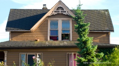
A prime example of the area’s endangered stock is the Lindsay Residence (1888), a Victorian at 144 East 6th Avenue near Main Street, and possibly the oldest extant house outside of downtown. Built just two years after the Great Fire, the old monarch sits adjacent to a former scrap-yard for sale as a development site. Clues to her former glory are still visible, including triple-assembly windows, and a shingled main gable with lunette window and original fascia details. Another grouping of seven houses at Ontario and 6th is a prime example of various residential styles of the early 20th century.
History
In 1869 the visionary Henry Valentine Edmonds, the clerk of the municipal council in New Westminster, acquired District Lot 200A—all of the wilderness land north of today’s Broadway in the future Mount Pleasant. He was speculating that Vancouver’s unusually fine natural harbour would someday become home to the terminal of a transcontinental railway, since he had witnessed first hand the pandemonium that ensued when San Francisco had been declared a transcontinental railway terminal.
During the 1870s a rickety bridge was built across the narrows on False Creek where Julius Voight had settled, firmly establishing the route south from Gastown that would later become Main Street, and the Hastings Sawmill acquired most of the remaining land in the Mount Pleasant area and chopped down the heavy timber for use in its lumber mill.
In 1887, as Edmonds had foreseen, the railway arrived and created spectacular growth in the newly named boomtown of Vancouver.
In 1888 a new bridge was built south across False Creek and Edmonds began to build streets in earnest. He named the new hillside subdivision “Mount Pleasant” after a village just outside of Dublin, Ireland, the birthplace of his wife Jane Edmonds. With co-owner Dr. Israel Powell, Edmonds began with the portion of Mount Pleasant north of Broadway.
In 1871 Dr. Powell was one of the key people who negotiated the entry of British Columbia into the country of Canada that had been created in 1867. In return, Canada agreed to build the Canadian Pacific Railway across thousands of miles of wilderness to the Pacific coast. Powell bought his extensive acreage in the future Mount Pleasant expecting to make a fortune in real estate after the railway that he negotiated arrived. He did indeed make a fortune.
By the late 1880s, the first houses appeared, giving birth to the City’s first neighbourhood south of False Creek.
By the early 1890s rapid growth had begun and would not let up until 1914 and World War I. The first streetcars reached Mount Pleasant by crossing the Westminster Avenue bridge (now Main Street) to their Front Street barns. In 1892 Westminster and 9th Avenues were serviced with the Fairview beltline.
In the ensuing decades, industrial uses crept southward, the area declined, and in the 1950s, property-owners successfully petitioned City Council to re-zone the neighbourhood for light industrial development. Since then, most of the early houses have been replaced by nondescript commercial buildings, but fascinating pockets of the old neighbourhood hang on, including turn-of-the-century houses, apartments and until recently dinners.
The City ‘s of Vancouver current update of the Mount Pleasant neighbourhood exclude this area. Hence, this area is still not on the radar for heritage retention and/or planning.
With the recent development of False Creek South, along with a lack of available development land downtown the pressure for redevelopment is increasing at breakneck speed. It is just a matter of time until we see further erosion of heritage resources in the area.
Position
Heritage Vancouver’s Position
The area is currently being ignored. If the City doesn’t act soon, there will not be anything significant left of this historic area’s early history.
The City of Vancouver should undertake a heritage survey of the area to determine potential heritage sites that have been missed, and flag them for planning attention. This will allow some time to develop possible solutions for the threatened structures in the area.
Creative ideas for retention should be examined. There may be opportunities, as was realized in Downtown South, to group surviving heritage resources within the context of new development.
In several cases downtown, threatened houses have been relocated to create a sense of the early neighbourhood history.

![3. Sir Guy Carleton School – Carleton Hall (1896) [saved]](http://heritagevancouver.org/wp-content/uploads/2011/11/HVS-Top10-795x440-carleton-400x284.jpg)

![7. Pantages Theatre (1907) [lost]](http://heritagevancouver.org/wp-content/uploads/2016/05/t10-pantages-B-795-400x284.jpg)